
Home >
About Us
Established in 1889, the International Boundary and Water Commission (IBWC) is responsible for applying the boundary and water treaties between the United States and Mexico and settling differences that may arise in their application. The IBWC is an international body composed of the United States Section and the Mexican Section, each headed by an Engineer-Commissioner appointed by his/her respective president. Each Section is administered independently of the other. The United States Section of the International Boundary and Water Commission (USIBWC) is a federal government agency and is headquartered in El Paso, Texas. The USIBWC operates under the foreign policy guidance of the Department of State. The Mexican Section is under the administrative supervision of the Mexican Ministry of Foreign Affairs and is headquartered in Ciudad Juarez, Chihuahua, Mexico.
The Convention of 1889 creating the International Boundary Commission (IBC), and the 1944 Treaty, which expanded its responsibilities and changed its name to the International Boundary and Water Commission (IBWC), both provide that it shall consist of a United States Section and a Mexican Section. The 1944 Treaty further provides that it shall in all respects have the status of an international body, that the head of each Section must be an Engineer Commissioner and that wherever Treaty provisions call for joint action or joint agreement by the two Governments such matters shall be handled by or through the Department of State of the United States and the Secretariat of Foreign Relations of Mexico.
The mission of the IBWC is to apply the rights and obligations which the Governments of the United States and Mexico assume under the numerous boundary and water treaties and related agreements, and to do so in a way that benefits the social and economic welfare of the peoples on the two sides of the boundary and improves relations between the two countries.
As provided for in the treaties and agreements, those rights and obligations include: distribution between the two countries of the waters of the Rio Grande and of the Colorado River; regulation and conservation of the waters of the Rio Grande for their use by the two countries by joint construction, operation and maintenance of international storage dams and reservoirs and plants for generating hydroelectric energy at the dams; regulation of the Colorado River waters allocated to Mexico; protection of lands along the river from floods by levee and floodway projects; solution of border sanitation and other border water quality problems; preservation of the Rio Grande and Colorado River as the international boundary; and demarcation of the land boundary.
The Commissioners meet frequently, alternating the place of meetings and are in almost daily contact with one another. Each Section maintains its own engineering staff, a secretary and such legal advisers and other assistants by what is identified in the treaty. Each Section also has field offices strategically located along the border to operate and maintain joint works and provide support in resolving binational issues. Each Government funds the cost of the operation of its Section of the IBWC, while the cost of joint projects is shared between the U.S. and Mexican Governments.
Implementation by the IBWC of broad provisions of treaties and other international agreements frequently requires specific agreements by the IBWC for planning, construction, operation and maintenance of joint works and to delineate the manner in which costs of joint project will be shared. Decisions of the Commission are subject to the approval of the two Governments and are recorded in the form of Minutes written in the English and Spanish Languages, signed by each Commissioner and attested by the Secretaries. Copies are forwarded to each Government within three days after being signed. Once approved by both Governments, the Minutes enter into force as binding obligations of the United States and Mexican Governments.
In addition to cooperative projects undertaken to implement existing treaties and international agreements, the U.S. and Mexican Commissioners make recommendations to their respective Governments for resolution of new or anticipated boundary or water problems. Early detection and evaluation of the problem and the development of measures for resolution are a part of the mission of the IBWC. Most problems are resolved by the development of new projects. The need for development of new cooperative projects may also be brought to the attention of the IBWC by one or both Governments, or by state or local authorities through their respective Section of the IBWC. If the findings of the IBWC joint investigations, recorded in a joint report of the Principal Engineers of the two Sections, show that a cooperative project is needed, is feasible and can be justified as an international project, the IBWC may endorse the findings in a Minute and recommend the project to the two Governments.
Once the project is authorized and funded by both Governments, each Government through its Section proceeds to perform under the joint supervision of the IBWC, its share of the work, as determined in the approved agreement.
The two Governments generally share the total costs of the projects in proportion to their respective benefits in cases of projects for mutual control and utilization of the waters of a boundary river, unless the Governments have predetermined by treaty the division of costs according to the nature of a project. In cases of man-made works in one country or operations in one country causing or threatening to cause damage in the other country, the cost is borne by the Government in whose territory the problem originated.
The United States Section prepares its assigned part of the plans for work or contracts for their preparation with other federal agencies or with private consulting engineers, awards contracts for, and supervises its part of the construction of a project under the overall supervision of the IBWC. The United States Section operates and maintains the part of the project assigned to the U.S. Government.
History of Commissioners
Since the 1920s, the following have served as United States Boundary Commissioners: Lawrence M. Lawson - 1927 to 1954; Colonel Leland H. Hewitt, (Tet.) - 1954 to 1962, Joseph F. Friedkin - 1962 to 1986; Narendra Gunaji - 1987 to 1994, John M. Bernal - 1994 to 2001, Carlos M. Ramirez - 2001 to 2002, Arturo Duran - 2004 to 2005, Carlos Marin - 2006 to 2008, Bill Ruth - 2008 to 2009, Edward Drusina - 2009 to 2018, Jayne Harkins - 2018 to 2021, Maria Elena-Giner - 2021 to 2025, and W.C. "Chad" McIntosh - 2025 to present.
The following have served as Mexican Boundary and /or Water Commissioners: Gustavo P. Serrano - 1923 to 1932 and 1935 to 1941, Armando Santacruz, Jr. - 1931 to 1936, Joaquin Pedro Cordova - 1936 to 1940, Rafael Fernandez MacGregor - 1941 to 1947, David Herrera Jordan - 1947 to 1979, Joaquin Bustamante Redondo - 1979 to 1985, Carlos Santibanez Mata - 1985 to 1989, Arturo Herrera Solis - 1989 to 2008, Roberto Salmon - 2008 to 2020, Dr. Humberto Marengo Mogollón - 2020 to 2021 and Adrianna Resendez - 2021 to present.
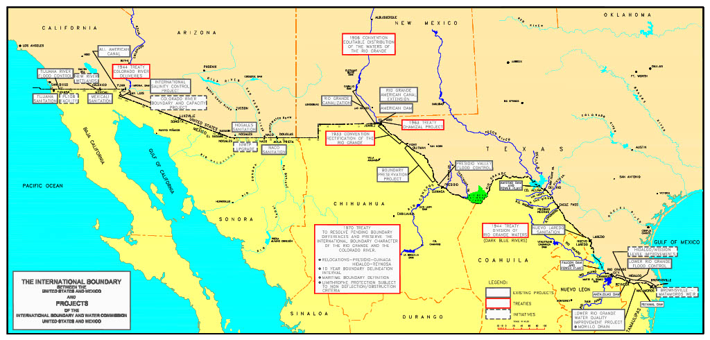
THE INTERNATIONAL BOUNDARY, United States and Mexico
As established by Treaties in 1848, 1853, and 1970, the boundary between the U.S. and Mexico extends 1,954 miles, excluding the maritime boundaries of 18 miles in the Pacific Ocean and 12 miles in the Gulf of Mexico. Beginning at the Gulf of Mexico, the U.S. – Mexico continental boundary follows the centerline of the Rio Grande a distance of 1,255 miles from the Gulf to a point in El Paso, Texas and Ciudad Juárez, Chihuahua. From this point, the boundary follows a westward alignment marked by monuments and markers overland below New Mexico and Arizona a distance of 534 miles to the Colorado River. The boundary continues northward along the centerline of the Colorado River for 24 miles, where it once again follows a westward alignment marked by monuments and markers overland below California to the Pacific Ocean a distance of 141 miles.
The region along the boundary is characterized by deserts, rugged mountains, abundant sunshine, and by two major rivers. These rivers, which make up approximately two-thirds of the international boundary, are the Colorado River and the Rio Grande. The rivers provide life-giving waters to the largely arid, but fertile lands along the rivers in both countries.
Although sparsely settled at the time of the 1848 and 1853 Treaties, the region rapidly developed with the emergence of the railroads in the 1880s and the development of irrigated agriculture after the turn of the century. In 2003, approximately 2.7 million acres of crop land was irrigated with the waters of the Rio Grande (1.6 million acres) and Colorado River (1.1 million acres) on both sides of the border. In addition, the Rio Grande provided 302.1 thousand acre-feet (13.16 million cubic feet) of water for municipal needs, which served over 3.7 million border residents in 2003.
Today the boundary is characterized by fifteen pairs of sister cities sustained by agriculture, import-export trade, service and tourism, and by a growing manufacturing sector. The U.S. Section estimates that between 12 and 13 million people presently live and/or work in the U.S. – Mexico border region.
The Guadalupe Hidalgo Treaty of February 2, 1848 established the international boundary. The Treaty of December 30, 1853 reestablished the southern boundary of New Mexico and Arizona to enable the United States to construct a railroad to the west coast along a southern route and to resolve a question arising from the 1848 Treaty as to the location of the southern boundary of New Mexico. Temporary commissions were formed by these boundary treaties to perform the first joint mission of the Government of the United States and Mexico, which was to survey and demarcate the boundary on the ground in accordance with the treaties. Another temporary commission was created by the Convention of July 29, 1852, which surveyed and increased the number of monuments marking the land boundary westward from El Paso, Texas and Ciudad Juárez, Chihuahua. As the settlements grew along the boundary rivers and the adjoining lands began to be developed for agriculture in the late Nineteenth Century, questions arose as to the location of the boundary when the rivers changed their course and transferred tracts of land from one side of the river to the other. The two Governments by the Convention of November 12, 1884 adopted certain rules designated to deal with such questions.
By the Convention of March 1, 1889, the Governments of the United States and Mexico created the International Boundary Commission (IBC), to consist of a United States Section and a Mexican Section. The IBC was charged with the application of the rules of the 1884 Convention, for the settlement of questions arising as to the location of the boundary when the rivers changed their course. That Convention was modified by the Banco Convention of March 20, 1905 to retain the Rio Grande and the Colorado River as the boundary.
The Convention of May 21, 1906 provided for the distribution between the United States and Mexico of the waters of the Rio Grande above Fort Quitman, Texas for the 89-mile (143 km) international boundary reach of the Rio Grande through the El Paso-Juárez Valley. This Convention allotted to Mexico 60,000 acre-feet annually of the waters of the Rio Grande to be delivered in accordance with a monthly schedule at the headgate to Mexico's Acequia Madre just above Juárez, Chihuahua. To facilitate such deliveries, the United States constructed, at its expense, the Elephant Butte Dam in its territory. The Convention includes the proviso that in case of extraordinary drought or serious accident to the irrigation system in the United States, the amount of water delivered to the Mexican Canal shall be diminished in the same proportion as the water delivered to lands under the irrigation system in the United States downstream of Elephant Butte Dam.
In the Convention of February 1, 1933, the two Governments agreed to jointly construct, operate and maintain, through the IBC, the Rio Grande Rectification Project, which straightened and stabilized the 155-mile (249 km) river boundary through the highly developed El Paso-Juárez Valley. The project further provided for the control of the river's floods through this Valley.
The Treaty of February 3, 1944 for "Utilization of Waters of the Colorado and Tijuana Rivers and of the Rio Grande" distributed between the two countries the waters of the Rio Grande from Fort Quitman to the Gulf of Mexico, and the waters of the Colorado River. Of the waters of the Rio Grande, the Treaty allocates to Mexico: (1) all of the waters reaching the main channel of the Rio Grande from the San Juan and Alamo Rivers, including the return flows from the lands irrigated from those two rivers; (2) two-thirds of the flow in the main channel of the Rio Grande from the measured Conchos, San Diego, San Rodrigo, Escondido and Salado Rivers, and the Las Vacas Arroyo, subject to certain provisions; and (3) one-half of all other flows occurring in the main channel of the Rio Grande downstream from Fort Quitman. The Treaty allots to the United States: (1) all of the waters reaching the main channel of the Rio Grande from the Pecos and Devils Rivers, Goodenough Spring and Alamito, Terlingua, San Felipe and Pinto Creeks; (2) one-third of the flow reaching the main channel of the river from the six named measured tributaries from Mexico and provides that this third shall not be less, as an average amount in cycles of five consecutive years, than 350,000 acre-feet annually; and (3) one-half of all other flows occurring in the main channel of the Rio Grande downstream from Fort Quitman.
The 1944 Treaty further provided for the two Governments to jointly construct, operate and maintain on the main channel of the Rio Grande the dams required for the conservation, storage and regulation of the greatest quantity of the annual flow of the river to enable each country to make optimum use of its allotted waters.
The 1944 Treaty provides that of the waters of the Colorado River there are allotted to Mexico: (1) a guaranteed annual quantity of 1.5 million acre-feet to be delivered in accordance with schedules formulated in advance by Mexico within specified limitations; and (2) any other waters arriving at the Mexican points of diversion under certain understandings. To enable diversion of Mexico's allotted waters, the Treaty provided for the construction by Mexico of a main diversion structure in the Colorado River, below the point where the California-Baja California land boundary line intersects the river. It also provided for the construction at Mexico's expense of such works as may be needed in the United States to protect its lands from such floods and seepage as might result from the construction and operation of the diversion structure.
In the 1944 Treaty, the two Governments agreed to give preferential attention to the solution of all border sanitation problems.
This Treaty entrusts the International Boundary and Water Commission (IBWC) with the application of its terms, the regulation and exercise of the rights and obligations which the two Governments assumed thereunder, and the settlement of all disputes to which its observance and execution may give rise. It changed the name of the International Boundary Commission (IBC) to the International Boundary and Water Commission (IBWC). The Treaty also provides that the IBWC study, investigate and report to the Governments on such hydroelectric facilities as the IBWC finds should be built at the international storage dams and on such flood control works, other than those specified in the Treaty, that the IBWC finds should be built on the boundary rivers, the estimated cost thereof, the part to be built by each Government, and to be operated and maintained by each through its Section of the IBWC.
Under the terms of the 1944 Treaty: the two Governments reached agreement for the solution of the international problem of the salinity of the Lower Colorado River, which was incorporated in Minute No. 242 of the IBWC dated August 30, 1973; and the IBWC submitted and the two Governments approved "Recommendations for the Solution of the Border Sanitation Problems," in Minute No. 261 dated September 24, 1979.
The Chamizal Convention of August 29, 1963 resolved the nearly 100-year-old boundary problem at El Paso, Texas-Juárez, Chihuahua, known as the Chamizal dispute, involving some 600 acres (243 hectares) of territory which were transferred from the south to the north bank of the Rio Grande by movement of the river during the latter part of the Nineteenth Century. By this Convention, the two Governments gave effect to a 1911 arbitration award under 1963 conditions. The Convention provided for the relocation of the IBWC of the 4.4 miles (7 km) of the channel of the Rio Grande so as to transfer a net amount of 437.18 acres (176.92 hectares) from the north to the south side of the river. President Lyndon Johnson met Mexican President Adolfo Lopez Mateos in El Paso on September 24, 1964 to commemorate the ratification of the Chamizal Convention.
The Treaty of November 23, 1970 resolved all pending boundary differences and provided for maintaining the Rio Grande and the Colorado River as the international boundary. The Rio Grande was reestablished as the boundary throughout its 1,254-mile (2,019 km) limitrophe section. The Treaty includes provisions for restoring and preserving the character of the Rio Grande as the international boundary where that character has been lost, to minimize changes in the channel, and to resolve problems of sovereignty that might arise due to future changes in the channel of the Rio Grande. It provides for procedures designed to avoid the loss of territory by either country incident to future changes in the river's course due causes other than lateral movement, incident to eroding one of its banks and depositing alluvium on the opposite bank. This Treaty, too, charged the IBWC with carrying out its provisions.